
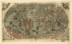
[1507] - 2.1 Мб
Первая карта, относимая к временам открытия Америки. Universalis cosmographia secundum
Ptholomaei traditionem et Americi Vespucii alioru[m]que
lustrationes.
|
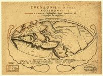
[1565] - 1.0 Мб
Основой для этой карты явилась более ранняя карта Джакомо Гастарди. |

[1581] - 490 кб
Карта с портретом сэра Фрэнсиса Дрэйка. |

[ок. 1595]
Показывает пути плавания сэра Фрэнсиса Дрэйка между 1577 и 1580 гг. и Томаса Кэвендиша между 1586 и 1588 гг.
|
[1630]
Дионисий в мире греков.
|

[1664?]
Новая точная всеобщая карта мира (Nova et accuratissima totius terrarum orbis tabula). |

[1716?]
Planiglobii terrestris cum
utroq hemisphжrio cжlesti generalis
reprжsentatio.
|

[1719]
A new (1719) & correct
map of the whole World. |

Gulf
Stream. Atlantic Ocean.
[1768]
Franklin-Folger chart of the Gulf Stream. Publication
authorized by Benjamin Franklin and Timothy
Folger.
|


East.
[1786] ------- West[1786]
Western New World or
Hemisphere. Eastern Old World or Hemisphere.
|

[1795]
Map of the World from the
best authorities. |

[1811]
Map of the world with the
most recent discoveries.
|

[1840]
He mau palapala aina, a me
na niele e pili ana. Hookahi ke pai ana. |


